Ahr catchment
Use the bars for loading the layers containing information related to basin conditions, characteristics and hydrodynamic analysis.
Land conditions
Land use: land use map for 2019.
The basin is mostly covered by forest and agricultural land (pastures, vineyards, etc.) representing around 87% of the total area. Urban areas (urban fabric, industrial, commercial units, sport and leisure facilities, etc.) represent around 5% of the land. The rest of the land is covered by mineral extraction sites and water bodies.
Soil type: soil is mostly divided in 3 zones composed of materials as follows:
- Eutric Cambisols – Haplic Luvisols
- Dystric and Eutric Cambisols
- Eutric Fluvisols – Chromic Luvisols
Historical events in the area
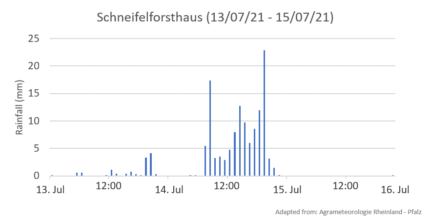
Between July 14th and 15th of 2021, an extreme event occurred in the Ahr catchment, affecting settlements and infrastructures along the river and over the floodplains. The event destroyed 3 gauges, interrupting the transfer of the data and the lost of important information.
The event caused 130 fatalities, and it was calculated a return period for the flood >1000 years. On July 14th the amount o rainfall recorded was around 150 mm.


During the event, the flow gage recording the discharge (water level) was damaged. Due to this reason, the register was not complete, and the peak discharge was not measured. However, using hydrological tools and modelization, a peak discharge between 400-700 m3/s was simulated.

