Catchment Name and Location: Tervuren is located in a region with a temperate climate. Based on the meteorological data of the Royal Meteorological Institute (RMI) at Ukkel, about 11 km from the study area, the long term annual rainfall is 780 mm and potential evaporation is 657 mm while the average 7 temperature is 14.1 °C during summer and 5.0°C during winter (Chormanski et al., 2008; Helmi et al., 2019). In recent years, parts of Tervuren have repeatedly faced localized pluvial floods that have been a nuisance to the residents (Smitz, 2021). LID practices could be a potential solution to the problem given their proven effectiveness in controlling stormwater. The urban catchment has an area of approximately 8.7 km2. The ground elevation ranges from 52 m to 121 m above sea level. In this catchment, 36% of the surface is covered with grasses 8 or shrubs, 32% is paved or built-up, 20% consists of trees, and 11% is allocated for crops. Loam is the most predominant soil type in the area.
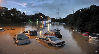
On 2005, the stormy weather was causing problems in Tervuren in Overijse, where flooding reduced car speeds to walking pace on the Woluwelaan in Sint- Stevens-Woluwe. There were also problems on the Tervurenlaan in Tervuren . The municipality of Tervuren will take measures to tackle flooding in several flood-prone streets. When it comes to water quality, use cases cover applications such as the effect of run-off and discharges on surface water (for example when mixed wastewater from the sewers enters a watercourse in periods of heavy rainfalls in a short amount of time.
Sustainable urban stormwater management has become more significant as cities face the effects of rapid urbanization and climate change. The impact of Nature based Solutions (NbS) on improving the quality of receiving water bodies and reduction of flooding in the urban catchment of Tervuren, Belgium would be assessed. This would be achieved using a Hydrologic & Hydrodynamic (H&H) model for stormwater calculations and the Low Impact Development (LID) locator tool for identifying suitable locations for porous pavements and green roofs.
Floods afecting Tervuren city